
Blue Oak Ranch Reserve is the ancestral homeland of two present-day tribes, the Muwekma Ohlone Tribe and the Tamien Nation.
Mákkin Mak Muwekma, ‘Akkoy Mak-Warep, Manne Mak Hiswi!
Welcome UC Berkeley Blue Oak Ranch Reserve to our Ancestral Thámien Muwekma Ohlone Territory of the Greater Santa Clara Valley
Introduction and Brief History of the Muwekma Ohlone Tribe

The present-day Muwekma Ohlone Tribe is comprised of all of the known surviving American Indian lineages aboriginal to the San Francisco Bay region who trace our ancestry through the Missions Santa Clara, San Jose; and San Francisco, and who were also members of the historic, Federally Recognized Verona Band of Alameda County. The aboriginal homeland of the Muwekma Ohlone Tribe includes the following counties: San Francisco, San Mateo, most of Santa Clara, Alameda, Contra Costa, and portions of Napa, Santa Cruz, Solano and San Joaquin. This large contiguous geographical area, which historically crosscuts several major linguistic and tribal boundaries, fell under the sphere of influence of the aforementioned three missions between 1776 and 1836. The missionization policies deployed by the Catholic Church and militarily supported by the Hispanic Empire, brought many distantly related, and in some cases, already inter-married tribal groups together at the missions.
Comprehensive genealogical analysis of the Mission Baptism, Death, and Marriage Records from the three Bay Area Missions traces the surviving Muwekma lineages of the late 19th century through today back to our aboriginal villages. The present-day tribally enrolled Muwekma lineages are represented by the: Armija/Thompson, the Santos-Piños/Juarez/Colos/Armija, the Guzman/Nonessa, and the Marine-Guzman-Peralta, Marine-Alvarez/Galvan, Marine-Sanchez, Marine-Munoz, Munoz-Guzman, Marine-Arellano, and Marine-Elston/Thompson/Ruano descended families.
The UC Berkeley Blue Oak Ranch Reserve and the Muwekma Ohlone ancestral heritage site CA-SCL-330, is located within the Thámien Ohlone (San Francisco Bay Costanoan) speaking territory, that embraces the ethnohistoric tribal groups of the greater Santa Clara Valley, which includes the lands of the Thámiens, Alsons, Matalans, and, specifically the Paleños — whose tribal region was named after their powerful chief Capitan Pala, as well as the two Mexican land grants located in the East Hills above San Jose — and who were intermarried with the direct ancestors of some of the lineages enrolled in the Muwekma Ohlone Tribe of the San Francisco Bay Area, whom were missionized into Missions Santa Clara, San Jose, and San Francisco.
This region also lies within the ancestral unceded tribal lands of the present day Muwekma Ohlone Tribe of the San Francisco Bay Area. Site CA-SCL-330 which the Tribe’s leadership and language committee named Chitcomini ’Árweh Wallaka-tka [meaning Place of Blue (Valley) Oak Rancheria Site], represents part of the reclamation process by Muwekma of its ancestral heritage sites, as a result of the colonial “Politics of Erasure.” The Muwekma Ohlone are also the legal successors of the sovereign, federally recognized, Verona Band of Alameda County. This land was and continues to be of great significance to our Tribe and other familial Indian descendants of the Verona Band.
*Please download the full greeting from the Muwekma Ohlone Tribe here*
It includes extensive documentation supporting the Federal reaffirmation of the Muwekma Ohlone Tribe
Blue Oak Ranch Reserve is the aboriginal homeland of Tamien Nation.
Tamien Nation enrolled Tribal citizens have direct lineages to precontact villages of the Greater Santa Clara Valley including the Ritocsi village (AKA San Cupertino Rancheria – Mountain View, Sunnyvale and Cupertino) San Juan Bautista Rancheria (Upper Guadalupe River to Central Coyote Creek), San Antonio Rancheria (east San Jose to Coyote Valley), Santa Clara Rancheria (site of Mission Santa Clara/University of Santa Clara), and San Francisco Solano Rancheria (site of Mission San Jose in Fremont). All enrolled Tribal citizens have direct lineages from Tamien villages verified by a certified genealogist and are direct lineal dependents of/or are on the California Judgment Fund Rolls (CJFR) of 1953 and 1972, and have Certificates of Degree of Indian Blood (CDIB) issued by the Bureau of Indian Affairs. Tamien Nation elders were also subject to the Indian Relocation Act of 1956 (also known as Public Law 959) implemented by the Bureau of Indian Affairs.
We acknowledge that Blue Oak Ranch Reserve is the aboriginal homeland of Tamien Nation since time immemorial and recognize the continued persistence and resilience of culture and community despite the adverse impacts of settler colonialism. The Tamien Nation continues to have a relationship with the land; one of deep respect, agreement, and reciprocity, collaborating to help maintain balance. Our organization acknowledges and supports Tamien Nation in solidarity and commitment to partnership, advocating for a more equitable and inclusive future.
*Please learn more about Tamien Nation by visiting https://www.tamien.org/*
Pre-Colonial BORR
The Ohlone of BORR spoke the Thámien/Tamien language. Prior to Spanish and American colonization, many tribes and languages persisted throughout the Bay Area and were connected through trade and alliances based on economic interests, territorial defense, marriage, and familial ties. The South Bay region transected several major linguistic boundaries (Tamien Ohlone, Northern Valley Yokuts, San Francisco Bay Ohlone, Patwin, Coast, Bay, and Plains Miwok). Many of these groups practiced the Kuksu religion, and the Tamien Ohlone and Bay Miwokan populations made up the southern reaches of the Kuksu interaction sphere in Northern California (Hedges, 2019).
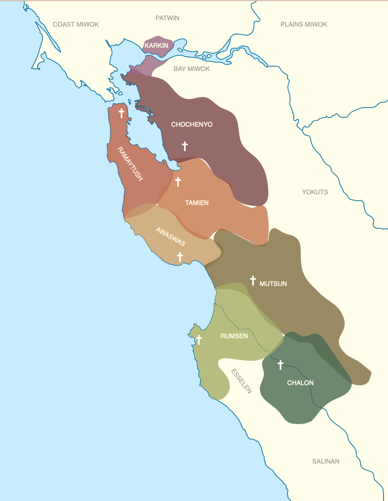
BORR’s headquarters are located in a valley that has supported dwellings for hundreds, or even thousands, of years. Rob Edwards (1984) first reported evidence of a large Ohlone village site in the large meadow south of where the Cedar Barn now stands. This village site is named Chitcomini ’Árweh Wallaka-tka by the Muwekma Ohlone Tribe (translated as Valley/Blue Oak Rancheria Site). In 2015, the UC Davis Archaeology Field School worked with the Muwekma Ohlone Tribe to survey Chitcomini ’Árweh Wallaka-tka. They identified olivella shell beads, flake stone tools, ground stone tools, and the burial remains of inhabitants who lived in this village site from 200 to 500 years ago. The group concluded that people lived here year-round, heavily utilized seeds and acorns, and made trips to the ocean, bringing back only the smallest and lightest bivalves all the way home. Lasting evidence of habitation is present throughout the reserve, including midden sites and locations in which cupules and mordars were carved into the bedrock. Cupules are smaller and shallower than bedrock mortars and sometimes have symbolic or religious meaning, rather than a purely utilitarian function. The orientation of cupule patterns and tree plantings was, in some cases and perhaps at Blue Oak, used to demarcate celestial events such as solstices, equinoxes, lunar phenomena, and asterisms (Ron Bricmont, pers. comm.).
Post-Colonial BORR
Following the establishment of the Alta California mission system in 1769 by Franciscan missionaries, many Native people were forced to abandon their ancestral villages and live in mission settlements. Many Tamien-speaking Ohlone people became neophytes of Mission Santa Clara. Missionization was highly destructive to Native lifeways and, together with the ecological and economic disruptions caused by the expanding Spanish colonial empire, malnutrition, and the ensuing spread of European-introduced diseases, including smallpox and measles, the Ohlone people suffered a major demographic collapse. The timeline and degree to which the Ohlone of this area were evicted and missionized are not clear. At least some people persisted in place, including one Ohlone man reported to have died in Halls Valley in 1918 or 1919 (Ron Bricmont, pers. comm).
On August 9, 1839, José de Jesús Bernal, a Mexican citizen and Spanish descendant of the de Anza Expedition, was granted Rancho Cañada de Pala by the Mexican government (Gudde, 1960). The Mexican system of land title, reaffirmed in American courts, disregarded most Native American land claims. The name of the grant was derived from the Native people known as the Paleños, and their powerful chief, Captain Pala. The word pala, which translates as “shovel” in Spanish, means “water” in many Native Californian dialects. This 15,714-acre land grant included present-day Blue Oak Ranch Reserve, most of what is now Joseph Grant County Park, and other smallholdings. Bernal built a small, thatch-roofed adobe house on the rancho in 1838, a year before receiving the land grant, and raised cattle and horses. His family lived on the land for many years. The United States claimed California from Mexico in 1846 and passed the Federal Land Act of 1851, which required all landowners to file claims or lose the rights to land grants deeded under the former Mexican government. Bernal pursued his claim, but legal fees and court costs from fighting other settlers’ claims on the land piled up, eroding Bemal’s finances and drawing him into debt. After his death, his family sold parcels to pay legal fees and deeded a very large parcel to his attorney, Frederick Hall, to pay for processing his claim. Although Halls Valley is named for Hall, who was a prominent and prosperous lawyer in San Jose and the author of the first history of San Jose to be published, he never lived in the valley and didn’t own land there for long.
Bernal’s family won his claim to the property in 1868, well after he died, but the holdings had shrunk considerably in the process. Between 1850 and 1880, as many as six different families raised cattle and farmed the area now known as the Blue Oak Ranch Reserve. The foundation of the Guerraz family home is still visible near the Windmill Gate, and the cabin built by Amos White, who purchased land from Bernal in 1859, still stands today. Santa Clara County built Mount Hamilton Road in 1876 to construct Lick Observatory.
Joseph D. Grant, son of a wealthy San Francisco merchant, began buying most of the land in the area and, by 1900, owned most of the land that had been part of the Rancho Cañada de Pala land grant, as well as other contiguous lands. Grant used the property for grazing cattle and game hunting. He offered recreational use of the Pala Seca Cabin (which was located near the Sawtooth above Deer/Nile Creek) and the Amos White Cabin (on present-day BORR) to friends such as Leland Stanford and Herbert Hoover. Hoover stayed at Grant Ranch for more than a month after his election loss to Franklin Roosevelt.
Joseph D. Grant died in 1942. In the years after his death, his heirs sold off about half of his land (Ron Bricmont, pers. comm.). When his last remaining heir (daughter Josephine Grant McCreery) died in 1972, she bequeathed what remained of the land to the Save the Redwoods League and the Menninger Foundation of Kansas. Santa Clara County purchased the land in 1975 and created Joseph D. Grant County Park. The park currently occupies 10,882 acres, contiguous with the southern boundary of BORR.
From about 1940 to 1960, the Reserve lands were held by a few families that raised livestock and lived off of subsistence farming. In the 1960s, the lands were purchased by the MacDonald Land Company and consolidated into the current boundaries of the Blue Oak Ranch Reserve. MacDonald raised cattle until 1972, when the Rancho Pilon’s Ownership Group bought the land with plans to convert it to vineyards, complete with a reservoir system and hydroelectric power plant. Rancho Pilon’s plans were derailed by the property’s location on the Calaveras fault—a large reservoir had been planned to sit right on the fault—and by mitigation requirements to relocate proposed reservoirs that would have inundated archeological sites. In 1990, Rancho Pilon sold the land to the Blue Oak Trust.
Up to this time, far too many cattle were on the property for the steepness of the slopes and the soil development. The Blue Oak Trust removed cattle except for one cow named Gramps, who persisted until 1993. Gramps Pond is named after them.
In 2000, the Blue Oak Trust entered into a conservation easement agreement with The Nature Conservancy that restricts new development to 10 acres surrounding the current facilities, supporting TNC’s campaign to acquire open space for conservation in the Mount Hamilton Range. The campaign continues to work towards protecting up to 500,000 acres in the 1.2 million-acre region surrounding Mt. Hamilton. The Nature Conservancy has purchased land and/or acquired the development rights for more than 100,000 acres in the Mt. Hamilton area, including a conservation easement on the venerated 28,359-acre San Felipe Ranch—as well as the Willson Ranch, a 1,557-acre connection between Rancho Cañada de los Osos Reserve and Henry W. Coe State Park.
On December 1, 2007, the Blue Oak Ranch Trust transferred ownership of the 3,280-acre Ranch—and the beautiful Cedar Barn that they built in 1993—to the Regents of the University of California, creating the 36th reserve in the UC Natural Reserve System. UC Berkeley took ownership of the property, accepted the terms of the Conservation Easement, and formed an open space agreement with the County of Santa Clara. In addition to the land and the existing facilities, the Blue Oak Trust provided significant start-up capital and a lasting endowment that continues to support BORR’s operations and mission far into the future. California voters passed Proposition 84 in 2006, and BORR used these funds to renovate the barn and build new facilities and infrastructure specifically designed for a field station. These efforts were completed in February 2016. In 2018, California voters approved Proposition 68, which provided funding to improve roads and support off-grid solar power generation. Today, the field station is accessible year-round and can house over 50 individuals overnight.